Commissioner for Environmental Sustainability Dr Gillian Sparkes was a panellist and keynote speaker at ‘Spatial Science for Sustainable Development and Unlocking the Transformative Potential of the UN SDGs’ on November 18 and 19 as part of the two-day Zoom Victorian Spatial Showcase and eSummit opened by the Victorian Minister for Planning, the Hon. Richard Wynne. The conference is exploring the ways in which spatial technologies are enabling the SDGs.
Dr Sparkes participated in the opening panel session following inspiring presentations by DELWP’s Chief Executive and Registrar of Titles Melissa Harris and Michael Annear, Director of International and Movement Relations, Australian Red Cross.
The panel ‘Spatially enabling the Sustainable Development Goals’ was moderated by the @SSSI President and Executive Director Strategic Consulting & International Relations Spatial Vision, Zaffar Sadiq Mohamed-Ghouse with Griffith University Professor Cheryl Desha; GeoScience Australia’s Martin Brady; Interregional Advisor for the United Nations Greg Scott and Melbourne University Professor Abbas Rajabifard.
Dr Sparkes discussed the progress of her work implementing the SDGs in environmental reporting in Victoria; achievements to date through the SoE 2018 and the ambitious approach to operationalising the SDGs by the Commissioner outlined in the Science for Sustainable Development framework for the SoE 2023 tabled in the Victorian Parliament in June 2020. Dr Sparkes highlighted the importance of spatial data to measure progress against the SDGs and to turn ideas into actions.
In her keynote on November 19, Spatial Science for Sustainable Development and Unlocking the Transformative Potential of the SDGs, Dr Sparkes briefed delegates on reforms underway in environmental reporting in Victoria. “Spatial technology offers new levels of intelligence to quantify, analyse and unlock the transformative potential of the SDGs as a framework for decision making for sustainable development,” she said. “Data tells us what, spatially enabled data tells us where. Knowing where to act is critical to protect the environment and build resilient communities, location by location.”
For Dr Sparkes, this necessary shift to implementing the SDGs for SoE reporting requires a broadening of Victoria’s environmental monitoring and reporting systems leaning into the State’s myriad of data sources in order to address data gaps; quantify and measure progress against the SDGs; broaden the definition of data inputs; and encourage investment in new data acquisition methods.

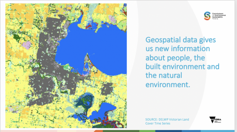
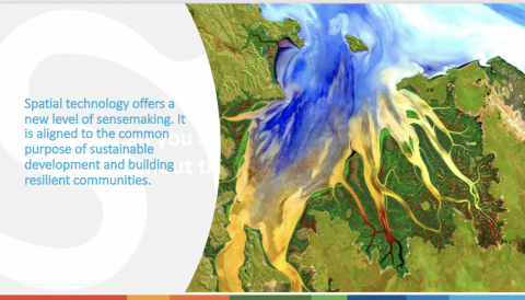
Dr Sparkes’ address outlined the Science for Sustainable Development Framework for the Victorian State of the Environment 2023 Report and the critical role of science, data and community in decision-making for ecologically sustainable development. The potential of spatial to deliver localised data was demonstrated through a series of powerful spatial imagery from sources including NASA, Geoscience Australia, Digital Earth Australia; FrontierSI; DELWP’s Victorian Land Cover Time Series and Digital Earth Australia – shedding new light on remote areas of Australia including Roebuck Bay, WA; the Pilbara Region, WA; and the Ord River Estuary, WA.
View the full slide deck here from the Victorian Spatial Showcase & eSummit.
Quick fact
Did you know that Victoria is one of only two jurisdictions in Australia (the other being the ACT) with an independent Commissioner charged with periodic State of the Environment reporting? Read about Victoria’s Commissioner for Environmental Sustainability.