The release of the Victorian Land Cover Time Series on 23 July 2020 by DELWP is an important milestone for land cover information gathering and how we view, interpret and analyse Victoria’s vegetation. It provides fascinating insights into land cover changes across the state between 1987 and 2019.
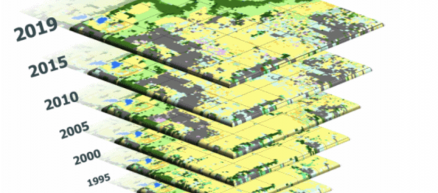
The dataset features spatial layers representing different time periods. Each layer presents the most likely land cover class for that area. It models land cover across the state, including native vegetation (herbaceous, woody and wetlands), intensive agriculture and recreation, forestry and the built environment, including urban areas.
The Commissioner for Environmental Sustainability Dr Gillian Sparkes says: “The Victorian Land Cover Time Series is a great resource not just for environmental decisionmakers but for the whole community. It aligns with recommendations in the Victorian State of the Environment 2018 Report (SoE) for better investment in, and use of, digital platforms and data analytics.”
The user-friendly Land Cover Time Series approach to mapping is multi-disciplinary combining:
- Freely accessible remote sensed data,
- Advanced computing techniques and processing, and
- Existing ecological data and knowledge.
Victoria has 19 land cover classes. Each 25m pixel of the layers displays one of these classes. As well as land cover classes it includes grassland restoration; dam to wetland transition; urban growth; and hardwood plantations in the south west.
Generating a consistent and repeatable statewide view of current and past vegetation cover, it allows for reporting on change trends over time and utilises statistical and machine-learning modelling to produce each of the seven land cover maps.
This Victorian Land Cover Time Series supports the analysis of the Biodiversity 2037 target of a net gain in overall extent and condition of habitats. It can also support a range of policy decisions, State of the Environment Reporting and many other potential uses.
The Victorian Land Cover Time Series datasets, methodologies and summary by location statistics (examples) can be accessed via the following links:
https://www.environment.vic.gov.au/biodiversity/Victorias-Land-Cover-Time-Series
http://services.land.vic.gov.au/SpatialDatamart/
NatureKit - DELWP's biodiversity web mapping and reporting tool (coming soon - August 2020)
Data.vic.gov.au - to download the land cover layers
Quick fact
Did you know that Victoria is one of only two jurisdictions in Australia (the other being the ACT) with an independent Commissioner charged with periodic State of the Environment reporting? Read about Victoria’s Commissioner for Environmental Sustainability.